Location: Nandi Hills
To get there: From Bangalore towards Hyderabad past the airport
Distance: Apprx 50km.
Date: 2nd July 2022
Trail type: Mostly (90%) manually created stone steps.
Facilities: Some roadside eateries at the trailhead where you can park also.
Map: Start point 
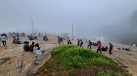
.jpeg) We reached the start point around 6.30am. The trailhead has some parking along the road leading up to it. A lot of vendors selling the usual roadside snacks, if you are up for it, are set up here. We had our packed breakfast and chose to start out without any delay. However, kids had their own schedule and we stopped within 15mins for our first round of treats! There are plenty of spots along the way to stop, take in the views, and have a picnic. We did that around 45 mins into the trek. The trail itself is not very long and we reached the top near the Nursery or Temple pond area in just over an hour. We then spent an hour there taking the bus to the Tipu Drop Point and then back. Climbing down was uneventful and quick and we were back in our cars by 9.30 heading back to Bangalore.
We reached the start point around 6.30am. The trailhead has some parking along the road leading up to it. A lot of vendors selling the usual roadside snacks, if you are up for it, are set up here. We had our packed breakfast and chose to start out without any delay. However, kids had their own schedule and we stopped within 15mins for our first round of treats! There are plenty of spots along the way to stop, take in the views, and have a picnic. We did that around 45 mins into the trek. The trail itself is not very long and we reached the top near the Nursery or Temple pond area in just over an hour. We then spent an hour there taking the bus to the Tipu Drop Point and then back. Climbing down was uneventful and quick and we were back in our cars by 9.30 heading back to Bangalore.

I had never really trekked up Nandi Hills in the numerous times I have gone there since my early childhood. We always drove up and if it was for birding we would just stop along the way at suitable birding points and do most of the wonderful Nandi birding at the top like we did on this trip in 2009. However, this time when a friend invited me to come along on a trek to reach the top via a backside trail, it was quite intriguing and I tagged along eagerly.

.jpeg) We reached the start point around 6.30am. The trailhead has some parking along the road leading up to it. A lot of vendors selling the usual roadside snacks, if you are up for it, are set up here. We had our packed breakfast and chose to start out without any delay. However, kids had their own schedule and we stopped within 15mins for our first round of treats! There are plenty of spots along the way to stop, take in the views, and have a picnic. We did that around 45 mins into the trek. The trail itself is not very long and we reached the top near the Nursery or Temple pond area in just over an hour. We then spent an hour there taking the bus to the Tipu Drop Point and then back. Climbing down was uneventful and quick and we were back in our cars by 9.30 heading back to Bangalore.
We reached the start point around 6.30am. The trailhead has some parking along the road leading up to it. A lot of vendors selling the usual roadside snacks, if you are up for it, are set up here. We had our packed breakfast and chose to start out without any delay. However, kids had their own schedule and we stopped within 15mins for our first round of treats! There are plenty of spots along the way to stop, take in the views, and have a picnic. We did that around 45 mins into the trek. The trail itself is not very long and we reached the top near the Nursery or Temple pond area in just over an hour. We then spent an hour there taking the bus to the Tipu Drop Point and then back. Climbing down was uneventful and quick and we were back in our cars by 9.30 heading back to Bangalore.

Overall an easy climb that you can do as an alternative to going by the busy main road to Nandi Hills and you get some great views and a workout as a bonus! Briding was very poor as the weather was cloudy and rainy some of the time.
As always, take only pictures and leave only footprints. Do not leave behind any trash on the trails.