Showing posts with label family trek. Show all posts

Makkalidurga: Trek for the views

First views of the formidable Makalidurga hill
Location: Makalidurga or Makkalidurga, Doddaballapura, Near Bangalore
Date: Dec 27th, 2015
To get there: [Click here for Google Map]. Go on Hebbal Road and take the exit to Doddaballapura a few kms after Hebbal Lake. Go through Doddaballapura towards Makalidurga. Trail head is  few kms after the Makallidurga Railway Station. You need to take a left on a dirt road just before a village(Gunjur) and go on that for about a km. Parking is next to the railway tracks.
Distance: 60km from Bangalore
Trail type: Rocky. Few places may need a bit of scrambling for the inexperienced trekkers.  Trail is marked with a white arrow painted on rocks in few places. At the top, there is a temple and fort which one can explore. We had kids aged 10 who did the trek quite easily. Still I would suggest to be careful as it was quite slippery in many spots due to small mountain streams. Also, younger kids can find it a bit strenuous.
Facilities: Doddaballapura is close by. Shops selling drinks and snacks are there on the main road near the trail head.


It had been a while since we had gone on any family trek close by. When a few friends also expressed interest to just go out and get relief from the City's chaos for a day at least, it seemed like our trek drought will end. After some internet research, we settled on Makalidurga near Doddaballapura even though it is on the other side of the city, as most reviews seemed to suggest that it a nice 1/2 day trek which is what we wanted.


Breakfast with a view!
Parking near the railway line
So, bright and early on the last Sunday of year 2015, 27th December, 4 adults, 2 kids and one teen set out in 2 cars northwards. We had packed sandwiches, fruits and snacks for our breakfast on the trek, some of which disappeared during the drive! Reached the trail head around 9, a bit late but not too bad. The Makalidurga hill towers over the railway line and the trail curves around a temple and them upwards. We met a few brave souls who had camped out at the top in the night.
White arrows to guide you in tricky places
Slippery slopes had to be maneuvered carefully

Truly scenic trails
View of the fort as we approached the top
Shortly after we started and as soon as we found a nice spot with some view, we settled down for a relaxed and pleasant breakfast. The trail from here goes around the hill and steadily up. It is clearly marked in few places with a white arrow. However, it is a bit of a scramble at some points and care should be taken to avoid an incident. I would suggest ensuring you have shoes with good soles to make it easier.
Fort walls

Fort ruins
At the top there are ruins of a fort and a small temple. Many paths and trails exist but no clear signs on where one should go or information boards about the fort. One can just explore the area as they see fit. We did one walk around and settled down on a boulder which gave a wide vista of the plains including the railway line near where we had parked our cars.

Black-shouldered Kite hovering over our lunch spot looking for its own lunch!
While relaxing there, we were treated to close up views of the hovering ability of the Black-shouldered Kite.There were also numerous Barn Swallows and Swifts putting on a nice aerobic display.

We finished up the rest of our food and started back. The trail back was somewhat easier. Or so we thought. By the time we reached our car though it was close to 2 pm and lunch was on everyone's minds. So, we stopped in Yelahanka on the way which had some good eateries. By evening we were back in our house after the much needed break from city pollution!

Hope to do the next one without such a long break!

If you do get to visit this or similar place around Bangalore, please ensure that you do not litter *anything* there to keep the place as pristine as possible for others.


Spotted a Common Kestrel as we were climbing down.
Trudging through some tall grass

Rose-ringed Parakeets


View of the railway line


Trekking to Dzongri La

At the viewpoint with Kanchenjunga in the background.

Location: Kanchenjunga National Park, Sikkim
Date:May 4th to 8th 2015
To get there: [Click here for Google Map].
From Bangalore, flight to Bagdogra or train to Siliguri and then drive.
Trail type: Wide trail paved with stones and logs. Some places are steep but scrambling not really required. I trekked whole time except the last part with camera and binoculars in hand
 Facilities: We had a full support group with 4 horses, cook, 3 helpers and guide all through the trek. 3-4 campsites are well established along the way where we can pitch our tents, get water and use toilet facilities. Couple of those places even had a small shop, selling most of the stuff that we may require suddenly like snacks, drinks, batteries, toilet paper and even feviqwik! which I needed as the sole of my shoes came off. 
You need the guides and local help though. Independent planning and trekking will be very difficult.
Misc Links:
http://trekking-in-sikkim.com/trekkings/dzongri-trek-4215m/


After getting great views of the Himalayas during a family trip to Manali few years back and hearing about the wonderful Himalayan treks from a friend we had been keen to do one ourselves. The opportunity presented itself when we had to drop our kid in Delhi and as we were wondering if we could add on a vacation along with it, a friends family suggested a trek in Sikkim. Suddenly everything fell into place and we had booked our flights, guide etc for the popular Dzongri Trek in early May.

Early planning was quite exciting for all, adults and kids. Hidden Paradise Adventures, who were our local guide and support team, sent us a list of things to get and be prepared for. Fact that we had to be ready for hot sun as well as snow and rain meant that we were in for an adventure. Kids of course were more interested in what snacks were going to be packed for the trip!

We joined with the second family in Yuksom after a few days stay at Gangtok, a wonderful city to visit. An overnight stay at Yuksom is recommended to acclimatize to the altitude at close to 2000mtrs. We met our guide Bhutia or Yuti for short, who briefed us on what to pack for our backpacks and what to put in our travel bags which would come with the Horses (or cross-bred yaks for some groups) to be used only at campsites.

Day 1: We started late around 10am as it was to be a fairly flat 8km hike to reach Sachen. This also helped us to get used to the altitude a bit. Within a short time of leaving Yuksom the views were fantastic. The lush forest, call of the birds, sounds of the many mountain streams, the bridges had us going without really feeling much of the effort we were putting. Highlight was sighting of Himalayan bears having a swim in a stream far away. Reached Sachen around 2 for lunch and then we just explored around the area until dinner around 7 (it becomes dark here by 6pm) and retired early at the tents set up by our support group.

Campsite at Tsokha
Day 2: Early morning and I mean early...it is bright by 5am! I was up for some great bird watching. Laughingthrushes, blackbirds and finches were all around the campsite. We washed up a bit using water piped in from a mountain stream. Icy cold! Breakfast was egg, oat meal and bread. All through this trip we were fed lots of carbs(mostly potatoes) as they kept reminding us to eat well because we needed that extra bit of energy for the trek, especially at this altitude. Soups were spiced with garlic and popcorn was added on as I believe they are good for higher altitudes. Today was a fairly hard climb to Tsokha which is at 3000mtrs. There was a brief rest stop at Bakim with great views. Here my shoes soles which was peeling off was fixed with feviqwik. Thankfully it sustained for the rest of the trek. From Bakim to Tsokha, the forest changed a bit to more decidous and spread out. Rhododendrons started appearing too. We also got to try out some wild strawberries, smaller but just as juicy. Reached Tsokha in time for lunch at 2pm or so.

Food can never taste as good as it does after a strenuous hike at high altitude. I mean we were devouring noodle soup as if it was made by the worlds greatest chef at the fanciest french restaurant all while sitting on a wooden bench (or ground sometimes) in a ramshackle hut!

Rhododendrons
Typical trails
Day 3: This was to be our hardest trek, Tsokha to Dzongri-La. By the way, La means Hill and Kan means Mountain. Steep trails, slippery ground supported by wooden logs, trekking at 3000+ mtrs. There was an abundance of Rhododendrons on this trail to keep our spirits up. We had lunch on the way at Phedang where our support staff had a hot lunch ready with temperature now dropping to below 10 c. We had one more steep climb here to reach close to 4000mtrs, where we were surrounded by thick mist, ie we were literally in the middle of clouds! After this the trail was fairly flat but with ups and downs. To test us further, there was rain with hailstorms during this part. We reached exhausted around 3pm at our campsite in Dzongri. One kid got a taste of AMS (Altitude Mountain Sickness). She took a nap which helped her recover. It was cloudy and dark here and we received a fair bit of snow in the evening to the children's delight. A wet and tired group, groped in the dark with torchlight for our beddings and retired for the night with Yuti promising to wake us up at 4am next morning provided the weather was clear for the final hike up to the Kanchenjunga View point. The prospect of a successful final climb looked bleak at this point.

Trek to Dzongri view point
Day 4: Yuti gave the early morning rooster call at 4am that the weather was indeed clear and we should set out asap. Miraculously, the exhaustion and depressive feeling of the previous night was gone from everyone! All of us set out in high spirits in pre-dawn light with the kids setting the pace up ahead. As the light started getting brighter, we were greeted with different spectacular views of the mountains. We could truly see and enjoy the majestic Himalayas up close. The trail was made even more beautiful with the fresh snow from previous day. The trail itself is very steep in the start and then flattens out to ridge trail to the view point. There were other groups already there to witness the dawn and sunrise from the view point. We made it in time for Sunrise and it was indeed all worth it. After rounds of group shots, selfies and enjoying the presence of Kanchenjunga, we scrambled down fairly quickly to be back at our campsite by 7am. A relaxed couple of hours allowed us to do some bird watching and take in a good picnic breakfast with pancakes. It was a much easier trek back to Tsokha where we camped at a different place for the last time on our trip. On the way we got some amazing sightings of the very beautiful and exotic Fire-tailed Sunbird.
Fire-tailed Sunbird

Day 5: Though it was going to be mostly downhill we were in for a strenuous hike as we had to do 16kms in a single day to reach Yuksom by 2pm. It was going to be 14kms from breakfast to lunch at 1am! So, start was early and progress was to be steady. But we still managed to stop by for a dip (of our legs!) in a mountain stream, eat some wild berries, get a sighting of the aptly named Scarlet Finch.

We were late by about an hour but enjoyed a relaxed lunch next to a mountain stream. Sore but happy, we washed up at Yuti's house, had some nice tea and set off on the long ride to Darjeeling our night stop, with our legs not required to do any work.

Final thoughts. Trekking in the Himalayas is wonderful. The mountain air and the views makes it spectacular. The altitude, weather and climb makes it challenging. So, its the whole package and definitely worthwhile if you can put up with some discomforts of living outdoors for a few nights. The flip side is it makes you appreciate what we have in our urban setting! :)

As always, when you are on the trail in these pristine environments, please take only photographs and leave only footprints. Avoid all littering and preserve the habitats.

More photos below. Do the slide show for my caption commentary!
https://picasaweb.google.com/108744378062761981880/DzongriTrekPeople
https://picasaweb.google.com/108744378062761981880/DzongriTrekNature

Videos:
Asian Black Bear sighting from far. (you can see it move in the last 10 seconds)
https://www.youtube.com/watch?v=zucIOFxneBM

GPS capture of some parts of our trek. With google earth plug-in you can experience a fly-by.
1. Yuksom to Sachen

2. Sachen to Tsokha

3. Tsokha to Dzongri

4. Climb to Dzongri view point (check the elevation gain graph on this)

5. Tsokha to Yuksom


Wild antelope in 2 hours!


Location: Jayamangali or Maidenahalli Blackbuck Reserve
Date: Jan 26th 2015
To get there: [Click here for Google Map].
From Bangalore take the Tumkur Road
Distance: About 115 kms from Bangalore and 60 kms from Tumkur
Trail type: Flat scrub jungle. It can be very hot in summer.
Facilities: Forest bungalow with skeletal staff. I believe overnight stay is possible with reservation done at Tumkur. Closest food places are at Madhugiri (20kms) so you need to pack a picnic and carry potable water. Many watchtowers are spread out on the sanctuary. Couple of them near the Forest bungalow are large ones from where one can do some relaxed nature watch. Many mud trails crisscross the reserve, most leading to a smaller watchtower.
Misc Links:
http://en.wikipedia.org/wiki/Jayamangali_Blackbuck_Reserve


Few people are aware that we have a sanctuary within a couple of hours drive from Bangalore primarily for the conservation of near threatened Blackbuck (Antilope cervicapra) which is the sole surviving species of the genus Antelope. And then there are some like us who knew about it but never got around to visiting! Well, that changed last week. :)

Republic day happened to be that magical day when we were all free, kids did not have any "must finish" homework and our friend and "guide" in Tumkur was also not tied up. We were up around 6 am, packed our sandwich lunch and were on the road by 7 am. About an hour later than what we had hoped. Thankfully, traffic was not too bad and we were at Pavithra Idli place, about 5 kms before Tumkur to rendezvous with and pick up our friend. After indulging in their famous "Thatte Idli" we were on our way towards the reserve by 9.30am which is quite late for birding. But as our birding focus was on raptors, specifically harriers on this trip, which stay active at high noon, it was acceptable.
Short-toed Snake Eagle

The drive which should have taken us around 90 mins instead took about an hour longer because of road construction activity and our own indulgence on birding along the way. The highlight was a large raptor perched on a boulder about 50 mtrs away from the road sometime before Madhugiri. We stopped and enjoyed its presence for almost 30 mins as it sat regally surveying the land around it constantly. Later, we were able to identify it as most likely a Short-toed Snake Eagle.
Chestnut-bellied Sandgrouse

We reached Jayamangali around 12 and as soon as we turned onto the mud road leading to the sanctuary, a peacefully resting Blackbuck under a tree gave us a fantastic visual treat. As we pulled away from there, my friend investigating what he thought was an odd-shaped rock at some distance realized that it was a Sandgrouse later identified as Chestnut-bellied. A wonderful sighting and a lifer for me. This elusive bird is hard to spot when at rest and we were indeed very lucky.
Southern Grey Shrike

Driving on, we saw many active shrikes including the rare Southern Grey Shrike found here which is a striking grey, black and white bird. Inside the Sanctuary we drove onto a nice area with a couple of pavilions, one at a height made for resting as well as bird or Blackbuck spotting. Binoculars is required as the area is vast and patience to let the animals show themselves. We had good views of Blackbucks ambling along or chasing each other. Harrier's activity was a bit less and our only luck was what we think was a Montagu's Harrier flying low on the ground, too far away to make any image.

Male ambling along
Male Blackbuck
We started back around 2.30pm and reached Tumkur at about 5pm with some stops along the way.

Female Blackbuck
The sanctuary itself is a scrub jungle and grassland. Some areas sadly have been destroyed in an ill-fated attempt at afforestation by planting trees destroying the habitat conducive to Blackbuck and Harriers. Many watchtowers and muddy tracks exists for those who wish to exert themselves a bit and walk around and get up-close encounters with the Blackbucks hopefully without disturbing them.

As always if you do visit, remember, Leave only Footprints, Kill only Time and Take only Photographs!


Male Surveying the visitors!


Birding in an urban Lake


Location: Puttenahalli Kere or Puttenahalli Lake, near JP Nagar, Bangalore
Date: Dec 15th, 2011
To get there: [Click here for Google Map].
It is located in South Bangalore next to Brigade Millenium.

Distance:  < 10Kms from Vidhana Soudha! :)
Trail type: Walking path going around the Lake. Educative and a good work out for kids aged 1 to 8. Too easy for older kids and adults. So, it is more of a nature walk for them.

Facilities: Benches to sit in few places. I did not notice any toilet facilities but should be there. Food, you are still in the city so plenty of places close by. Avoid picnicking. If you have to, get only finger food in reusable boxes and do not litter.

Pheasant-tailed Jacana


One of my favorite birds to spot whenever I see a lotus covered pond is the Pheasant-tailed Jacana. PTJ and its cousin Bronze-winged Jacana are 2 beautiful birds which gingerly walk on the wide leaves of the Lotus plants earning the name leaf-walkers. Nature has provided them with feet having long fingers which are suited for this type of life style.
Mom and Me! Common Coot 

Unfortunately, one usually needs to drive to the outskirts of Bangalore to spot them. Lalbagh and Yediyur Kere both of which contain lotus vegetation have not been successful in attracting and protecting these birds long enough for them to call it their homes. But, Puttennahalli Kere, in JP Nagar, is an exception now. This lake which was once a dump yard and encroached upon has been restored through a citizens initiative PNLIT led by Usha Rajagopalan. The key point in this restoration project is that, they have not made this lake into a "soup bowl" like Ulsoor, Sankey or Lalbagh tanks. The edges are left to nature to create an habitat which can sustain these and other birds.
Purple Swamphen

So, for us nature enthusiasts, we no longer need to drive 30-40 kilometers out of town to see these beautiful birds. One can take nature stroll, or ramble if you will, around this lake in the middle of Urban sprawl and enjoy them in leisure. When we went there, we also spotted many other equally colorful water birds such as Herons, Coots, Purple Swamphens, Lesser Whistling Teals and the migratory Garganeys.

So, if you have a couple of hours to spare one day and wish to observe and enjoy some nature, head out to this lake and you wont be disappointed.


As always, do not litter the place. Even though some spots may look bad, we don't really want to add to that, do we?

 Lesser Whistling Teal(open wing), Common Moorhen (Red knob),  Pheasant-tailed Jacana (foraging on left) and Garganeys (huddled at the top)

Workout with great views: Shivaganga near Tumkur

The peak from far
LocationShivaganga Peak, Near Tumkur
Date: Sept 25th, 2011
To get there: Go on NH4 Towards Tumkur. At Dobbaspet take a left under the flyover towards Shivaganga. There is a sign board immediately after you take this turn. Shivaganga is about 6 to 7km from here.
Distance: 60 km from Bangalore
Trail type: Crudely cut or man made steps on the hillock with some rocky path in between. There are railings for support when it gets too steep. It is going up almost all of the time, so one has to completely stop for a respite. The peak is at 1350m elevation, making it a gain of about 400 meters during the trek. Distance is around 2km. Trash can be seen all along the path though it was not as bad as in some other temple trails.
Facilities: Refreshments such as cut cucumber, soft drinks, bottled water, majjige, bajji, charmuri are available by trail side vendors at constant intervals along the trail.

MapClick here for the Google map.


This spot was picked for the first ever group trek by the residents of Brigade Classic Apartments as an easy to moderate trail. The group comprised of families with kids from 6 yr old to 15yrs. It was finally a total of about 25 of us who set out in a bus at around 7am with a packed brunch and plenty of energy for a good workout. As it was a Sunday, it took us less than 2 hours to reach Shivaganga town. The traffic was light and the new elevated freeway up to Nelamangala made the drive even smoother. Some fun games like Dumb Charades and 20 questions helped us reach "quicker".


The trail starts from the main road close to the temple tank as a flight of steps leading to the base temple. To go to the top you have to turn left just before you enter the temple compound. We chose to carry the packed lunch of Idlis and Karabath to picnic on the trail taking a chance on the warnings about monkeys which we were told liked to give company. More on that later.


It is a steady climb all through and will be quite tiring if you attempt to do it too fast. The best way is to go slow enjoying the views and taking rest as required. We made 3-4 stops on the way for coffee, fruits, water, etc., All of our group right from 5 yrs to almost 50 made it to the Shiva Ganga statues after about 2km trek and 300 meters gain. On the man made steps, it is easier to navigate though steeper while on the undeveloped parts of the trail one has to be careful about slipping on the small rocks. 


The monkeys. Well, they kept us company all through the trail. A few times they were aggressive enough to come close and sniff at the bags or, as it happened, at a lollipop that a child was sucking on. It did not go away until the lollipop was gifted to it. Advice: Do not carry any exposed food item! So, here we were hungry and ready to picnic but not at all comfortable with the patiently stalking monkeys waiting for their share of the food. A kind vendor came to our rescue by allowing us to use a barred enclosure behind the statues. This worked well though when you think about it, we were in the cages feeding while the monkeys were free outside looking in at us! Gives a different perspective to the "zoo" experience. :)


After the refreshments, about 8 of us chose to go ahead and reach the peak while the rest decided to head back. The final 100m climb is a very steep climb on man made steps. It is quite strenuous though there is adequate support in railings. But we made it, even a little one at less than 6 yrs. At the top there is a Gangadeshwara temple also marked as Dakshina Kashi and a Nandi on an adjacent rocky outcrop. 


After spending a few minutes there, we started our descent which is a little more trickier and prone to accidents if one is not careful due to the steep gradient. We managed to get down fairly quickly with no mishaps. 


There was not much birding to do. We could see and hear White-browed Bulbuls all over, Purple-rumped Sunbird and many Black kites hovering overhead. Highlight, could be a possible Thrush or Robin on which I will update here, if I am able to find its ID. (Confirmed now. It was indeed a Blue Rock Thrush one of the first visitors to India this migrant season)


Overall, it is a nice trek if one is looking for some challenge without it becoming too difficult. I would think kids 8yrs or more should be able to do it with some exceptions both ways. After lunching at Kamat Upachar which is located on NH4 few kilometers after Dobbaspet, we were back home around 4pm with some well-earned aches and pains! :)

Some more images from the trek are here.

Climbing Chamundi Hills


Location: Chamundi Hills, Mysore
Date: Apr 3rd, 2011
To get there: Chamundi Hills is a well known landmark and visible from anywhere in Mysore city and anyone will be able to guide you. Ask for the steps to climb it as you get close else they will direct you to the road going up.
Distance: 150 km from Bangalore
Trail type: Flight of stone steps, about 1000 in number.
Facilities: Refreshments are available at the top. At the start and on the path also if you start late.
Map: Click here for the Google map.


It was a friends with family get-together that got us to stay at a resort in Mysore close to Chamundi Hills. A few of us took the chance to do a good trek and shed some of the calories that we were surely going to gain in the all-you-can-eat breakfast buffet everyday. The choice was to climb up Chamundi Hills, yes, using our own god given 2 legs.

Even though, I have been to Mysore many times, this was the first time I actually did this climb. After getting directions we found the start of the steps. There is ample parking and some shops here. When we reached the place at about 7am on a Sunday, there were quite a number of people already coming down!

The steps are just like that for any of the numerous hill temples in India. We didn't count them, but I believe it is about a 1000!

For me of course, it was a chance to look for some birds along the way. However, it was disappointing as the Great Tit turned out be the best sighting. There was also a quick glimpse of Common Iora and another uncommon flycatcher which flew away before I could view and ID it properly.

The climb itself is not too strenuous if done in a proper pace taking rests at good view points. We did it under an hour and were fine after. The steps end close to the temple and you can immediately buy some rejuvenating tender coconut or Nandini flavoured milk to reward yourself. :)

The views are better enjoyed coming down and you can see the palace grounds and most of Mysore on a good clear day.

Start early...preferably right after day breaks. Give yourself 2-3 hrs to complete the trek. Carry some water/snacks and as always don't add to the trash that is already there! Enjoy.

All are welcome at Ranganathittu Bird Sanctuary


Location: Ranganthittu Bird Sanctuary near Srirangapatna
Date: Feb 6th 2011
To get there: [Click here for Google Map].
From Bangalore take the Mysore Road. After you cross Srirangapatna fort (main junction with Fort Entrance on right), watch out for the Sanctuary board on the right after about a km. It comes right after you cross 2 bridges. Take the right and drive along a country road for another km or so and you are there. From Mysore side, it is even closer. Just reverse the directions above.
Distance: About 125 kms from Bangalore and 15 kms from Mysore.
Trail type: There are no trekking trails that I am aware of here. I have noticed a dirt track going to the left of the boating point. We have only gone about 200 mtrs (due to lack of time) on it so not sure how much further one can walk. However, it has ample space, including a maze with hedge walls, for kids to enjoy.
Facilities: Fairly decent KSTDC run eating place and toilet facilities. Srirangapatna and Mysore are close by.
Misc Links:

In case you wondered, the "All are welcome" in the title was meant for the birds since we 2 legged, non-flying, large brained but prefer to travel in machines species, have to pay dearly to enter this place! Well, I think it is not
too high considering the natural wealth this place possesses, but then I may be in the minority with this view. We paid Rs. 50/person to enter. Boating is again Rs. 50/person in the general boat or (a very steep) Rs. 1000 for your own boat which can seat 8 persons.

We ended up there Sunday morning in keeping with a promise along with another family to go "someplace nice" post New year. 1 month too late, but we made it. Left Bangalore around 6.30am, lunch near Maddur about 9am and we were at the Sanctuary before 11am. A bit late but early enough to enjoy the place.

The place itself is a bunch of islets in the river Cauvery providing
natural protection to nesting migratory birds. There are only rowboats
to keep the disturbance to the birds minimal. Guides are quite knowledgeable about the birds which inhabit the sanctuary including their migration patterns and characteristics. Do not hesitate to ask them questions.

There is really no season as such because you will find some activity all-round the year even if it is just resident birds. During the migratory season which varies according to each species and is from Oct to about June, you will find each species in different stages like arrival, nest building, chick rearing and finally lessons on flying before heading
back to their home. During our visit, we got to see Painted Storks, Asian Open-billed storks (nesting), Eurasian Spoonbill (nest building), Spot-billed Pelicans prominently in the trees. Others were Great Thick-knee (or Great stone plover), Marsh Harrier (migrant), River Tern, Night Heron, etc. You will also surely spot few crocodiles which is a thrill for all the youngsters.

The facility has some space around it to picnic or just hang around. There is also a maze made of hedges which our youngsters enjoyed. After a quick stop-over to see Daria Daulat Bagh, Tipu's summer palace, we headed out to make it for a late lunch at McDonalds(kids choice), which is few kms after Maddur on the way back. Reached Bangalore by 7pm.

Overall, a must visit if you are a nature enthusiast and live around Mysore or Bangalore. Perfect for a day trip or even a 1/2 day trip. I would recommend reaching there before 10am, ideally 9am to be able to experience and photograph better in the morning light.

Click here for more images from the trip.


Savandurga : Adventurous Rock Climbing

Location: Savandurga
Date: Nov 1st 2010
To get there: [Click here for Google Map].
There are 2 routes to reach the place from Bangalore.
1) Take the Mysore Road. Turn right after Kengeri, right after Rajarajeshwari Dental College. There is break in the divider here and the road leads to Big Banyan Tree and Country Club. Go along this road passing Big Banyan on the way until you reach an intersection in the middle of a village. Turn left here towards Manchinbele (ask somebody just to make sure). Go past Manchinbele Reservoir (on the right) until you come to an Village where there is a sign to turn right for Savandurga. Now the road goes through some wonderful greenery. After about 10km, you will see a right turn with a big signboard for Savandurga, facing the other way though. Some shops with lot of Autos will be there. Ask to confirm you are the right track. About 4km after this you will reach Savandurga.
2)(We returned by this route) Go on Magadi Road past Tavarekere and Thippagondanahalli. You need to take a left towards Savandurga before you reach Magadi. Best to ask when you are about 6-8 kms from Magadi. Then its a left from this road where the big signboard is.
Distance: About 70kms from Bangalore
Trail type: Solid rock! Savandurga's 2 hills Billigudda and Karigudda are Monoliths. So, you are walking on rock surface at a fairly decent incline. Route is marked with white arrows. A local person latched on to us as a guide and he was able to show us a route which even my 5 yr old managed without being carried. However we only went 1/2 way so not sure after that. Beware that climbing in wet conditions is probably very dangerous.
Facilities: Several shops sell snacks and water near the temple at the base. Some basic dhabha type hotels were also present. We did not try them as we had carried our food. Magadi, I am sure will have decent hotels. Toilets... hmm...you are on your own. Our guide let us use the marriage hall.


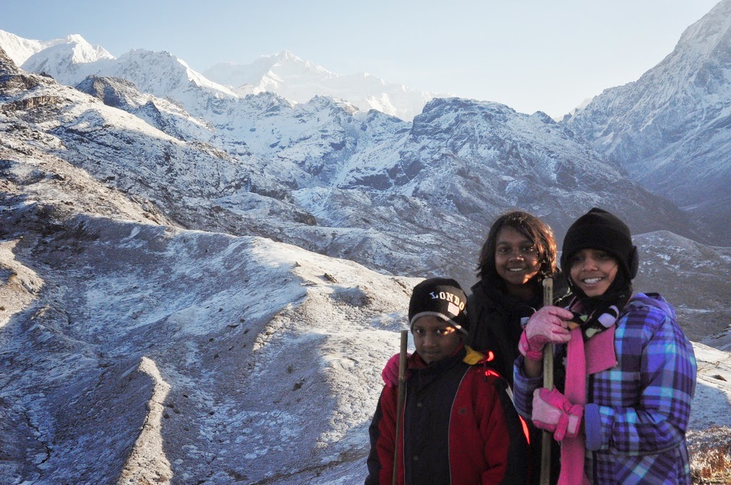
It had been some time since we had done a family trek close to Bangalore. Nov 1st being Kannada Rajyotsava which made Monday a holiday, it seemed like a crime to let it go waste. So, us and Bipin, my college friends family, started searching for a nice place to go. It had to be kid friendly as between us we had a 12(kruthi), 9 (Nithila), 7(Samitha), 5 (Swarup) yr olds. Finally, it was the Kruthi who suggested Savandurga. We settled on it after a quick Internet research and it turned out to be a great choice!

We started out around 7.30 choosing route 1) as it was closer to us. By 9am we were at the Big Banyan tree. After stopping to take in the sight of this large tree, we continued until we crested a hill and came upon the magnificent view of Manchinbele reservoir. Using our experience during our last visit here, we decided to take the road along the reservoir for a short distance and have our picnic breakfast by the side of the reservoir. Kids were of course happy with that decision!


All along, this trail we birded where ever we could. Highlight was about 25 Baya weaver nests in a roadside Palmyra tree, half of which seemed active with birds building, fixing and just living in them. Doves, bulbuls, sunbirds, cormorants could be seen all along the way. Manchinbele hosted lots of Red-rumped Swallows, some Grey Herons and a pair of Spot-billed Ducks among others.


We proceeded along some beautiful roads and quite thick forest to Savandurga. The hills looked magnificent as we approached it. Soon we were parked opposite to the temple and asking for directions to the start of the trail. Everybody knew it! An old local man, Mr Rajanna, approached us asking if we needed a guide. We were not sure. He hired himself as our guide and tagged along. After seeing the menacing the rock surface, we decided to let him take charge. That was a good decision as he chose good routes and helped the kids over tough parts. This I think is the easier Billigudda, though we never did ask anybody there. The other Karigudda is supposedly much more difficult to climb.


The climb itself is awesome for anybody who does not do much rock climbing. The slope is not too daunting once you get used to it and feels quite adventurous to trek over. Since we had only couple of hours and with small kids we asked our guide to lead us only half way up where one can find remnants of Kempe Gowda's fort. The kids had a whale of a time scrambling over the hills to reach this spot which is about one km from the starting point and with 100 mtrs or so elevation gain.


The views from here were fantastic. We savoured it over cookies, drinks, chips and what not for more than 30 mins. Reluctantly as thunder clouds started moving in, we descended fairly quickly to the trail head near the temple. After a well deserved tender coconut, sandwiches and snacks, we headed back to Bangalore around 2pm.

This time we took the Magadi route, then hopped on to NICE road after Tavarekere to exit at Banashankari via the Link Road or PES College Exit. At 62Rs it was close to a rip-off but both the Magadi and NICE Roads made the drive easier and maybe it was worth it.

So, what do I think of this place? I recommend it as a great spot for an adventurous family outing. The drive along Machinbele and the forest before Savandurga adds to the experience. The trek or climb itself is quite exhilarating and kids are sure to enjoy it provided due precautions are taken. Wear good shoes and don't do anything stupid like running up or down, especially when the shoes get wet in the various small streams of water. Rajanna or Thathappa as we called him warned us about many mishaps ending in broken bones.


As always, if you do choose to trek here, take all the photos you wish and leave only footprints, that is, if you can on the rock! Yes, I mean do not litter and keep the area clean which it surprisingly was compared to other such spots in Bangalore.


More photos can be found at: